
When there’s an earthquake, be it under our feet or on the other side of the world, having reliable information quickly available is essential for several reasons, first of all our safety. We usually obtain this information from our preferred news sources or, increasingly, from social media. But where does this information come from? Who provides magnitude, depth and location of an earthquake?
The bodies involved in seismic monitoring, that is, those involved in detecting earthquakes, are different and usually each nation has its own. Three of the most important for earthquake monitoring in Italy and in the world are the National Institute of Geophysics and Volcanology (INGV), the United States Geological Survey (USGS), and the Euro-Mediterranean Seismological Center (CSEM-EMSC).
INGVterremoti
The first reference is the Istituto Nazionale di Geofisica e Vulcanologia (INGV), in charge for the seismic monitoring in Italy. The information it provides is available across multiple channels, but primarily through the terremoti.ingv.it website. Here earthquakes are classified according to date (from most to least recent), magnitude (from strongest to weakest) and zone.
Data comes directly from the INGV Seismic Room, where operators assigned to seismic monitoring work 24/7 to validate the outputs within 30 minutes from the earthquake.
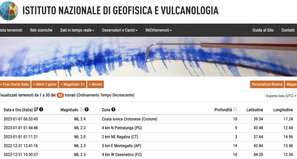
The same data is available on the INGVterremoti app, which also allows the sorting of earthquakes based on the distance from where one is (thus particularly useful for understanding if the vibration we felt was a real shock or just our imagination).
If app and website do not suffice, INGV has also a Facebook page and a Twitter account: here not only the automatic estimates are posted within minutes from an earthquake, but within 30 minutes the validated (i.e. verified) data is available.
Bonus: the app contains a “Story Maps” section that collects insights into the most relevant events of the recent past.
United States Geological Survey
Across the pond the United States Geological Survey (USGS) is the reference. Like INGV, also USGS is involved in the seismic monitoring at the national and global scale and makes its data available on its website and social media, mainly Twitter. On this platform there are seven USGS accounts dedicated to earthquakes: from the bot account that posts real time data, to the one dedicated to outreach, up to the one dedicated to seismic instrumentation and the one of the ShakeAlert programme, an early warning system to alert the population a few seconds before an earthquake strikes (they may seem a few, but especially when it comes to big magnitude earthquakes, these few seconds can become crucial).

Bonus: the website has a world map on which the latest earthquakes are indicated. It is possible to decide what to use as a map, for example only the sea floor, continents or roads. In addition, the plate edges are indicated and only for the US, the main faults are shown… and I recommend to have a look at the San Francisco area!
European Mediterranean Seismological Centre
The third reference is the European Mediterranean Seismological Centre (EMSC), a scientific NGO founded in 1975 which combines the seismological observations at the Euro-Mediterranean level of 85 institutes from 56 different countries. Although also in this case magnitude, date and location are available for each earthquake on the website, there are actually three bonuses.
The first is the LastQuake app, which, in addition to showing the earthquakes closest to where we are, allows also the searching for only the most significant events. But above all, it signals a possible tsunami alert and if it is later withdrawn. Moreover, if the user felt the earthquake, he/she can contribute by writing a comment and/or uploading an image.

The second bonus is the @LastQuake Twitter account, which not only tweets about earthquakes in real time, but provides also interesting insights during the events.
Last but not least is the Telegram channel LastQuake2: in addition to real time earthquakes it shows also other information, like shakes maps obtained merging the data provided by citizens.
Why three references?
One reference is (or rather, should) be more than enough to keep up with the latests earthquakes. And, in most cases, it is. Other times, however, it may happen that different sources give different values.
The three examples described above provide the information they calculate for each earthquake and often (actually, almost always), the values obtained are slightly different from each other. In other words, for the same earthquake, magnitude and epicentre depth are similar, but not the same.
While this may seem a contradiction, it really isn’t. When it comes to locating an earthquake, what technicians and seismologists do is estimate these values through seismic waves propagations models, based on the current available knowledge. Furthermore, when it comes to magnitude, there is no single definition, rather several suitable for different events (e.g. earthquakes occurring under a volcano or with magnitude higher than 6.0).
Since we are talking about estimates, it is normal that there are differences, given that the tools used (the models), the information (seismograms collected by seismometers) and the type of estimated magnitude are different. A bit like if we all had to estimate the height of a building, each using its own information (how many floors the building has, how high each floor is, etc.), perhaps with a different definition of height (for me is from the ground floor to the top floor, for another person it also includes the roof). Eventually we would get similar, but not the same, values. Therefore, there are no exact magnitude and depth values for each event, but estimates that are close to each other, which provide an idea of the characteristics of the earthquake.